What El Niño means for fire and flood season
This year, fire season and flood season may not happen back to back — they may overlap. A strong, early El Niño is driving Pacific storms further south, while burn scars from this year’s wildfires prevent the ground from absorbing rain.
Pete Curran, Staff Meteorologist at Watch Duty, breaks down what's actually happening in the Pacific, what it means heading into fall and winter, and why you shouldn't believe everything you read about a 'super El Niño.'
What is El Niño, exactly?
El Niño is a warming of the ocean along the equatorial Pacific. Forecasters track it in a specific patch of ocean, measuring how far sea surface temperatures rise above average. El Niño warming is categorized as anywhere from ‘weak’ to ‘very strong,’ with ‘very strong’ referring to when the ocean surface is more than 2°C above average.
There is no 'super El Nino' level – that is a nickname popularized on social media and in some reporting. (The official scale stops at 'very strong.')
This year, conditions were neutral as recently as February. But since then, temperatures have jumped above average.
"We're already in the strong to very strong range of temperatures, even though this is months before El Niño typically peaks," Pete says. Some forecasts show temperatures approaching 3° to 3.5° above average by winter.
How will El Niño affect flooding and fire season?
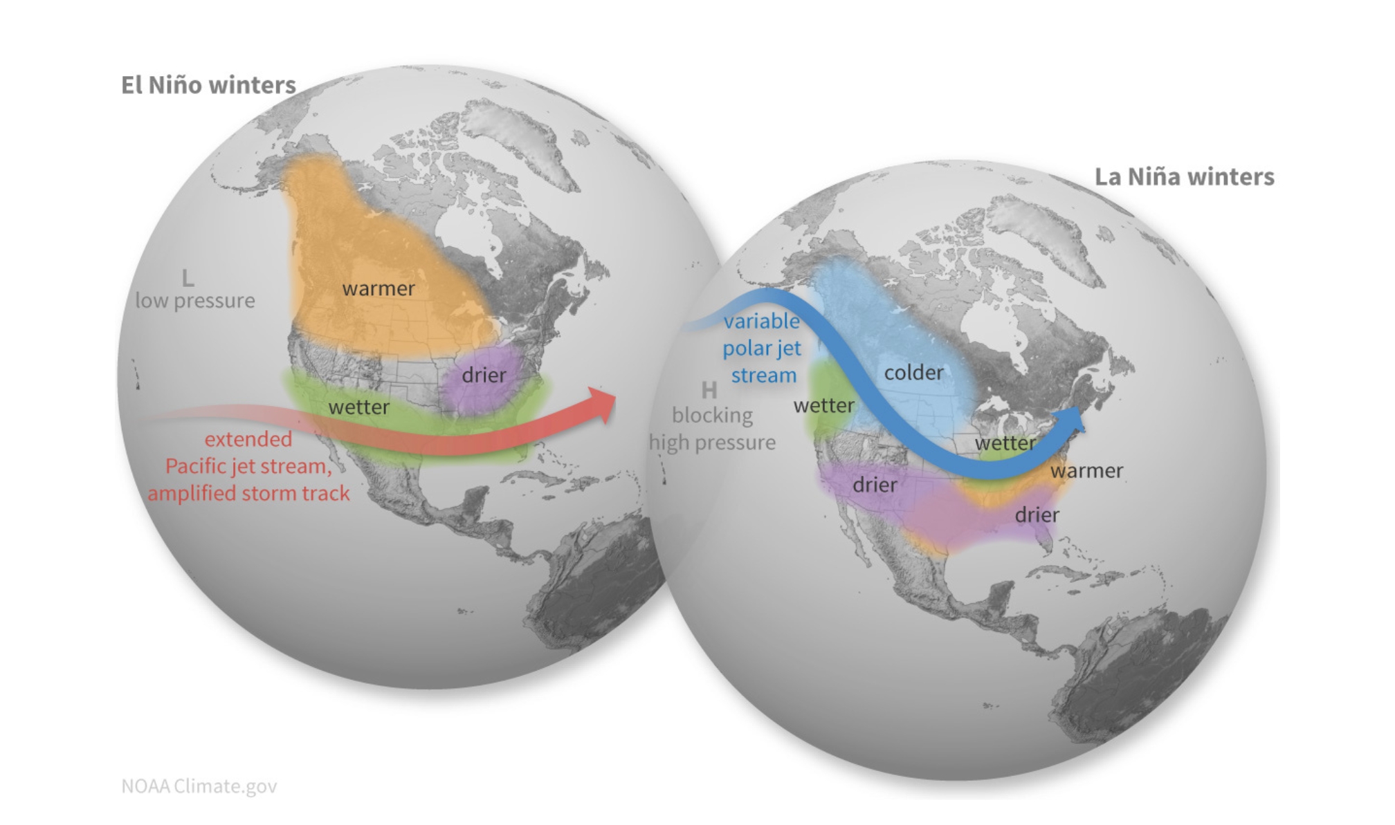
A strong El Niño typically pushes Pacific storms towards California and the southern U.S., rather than their usual path towards the Pacific Northwest. This shift can also affect conditions across the country, leading to wetter and stormier conditions across Texas and the Gulf Coast, and drier weather in the northern tier of the US.
El Niño can also cause sea levels on the Pacific Coast to rise by as much as 6-12 inches, which when coupled with astronomical high (King) tides and high surf and swell caused by winter storms, can result in major coastal inundation and flooding of residential areas and transportation corridors.
When multiple rain storms occur over successive days, saturated ground can no longer absorb rain, raising the risk of flash flooding. Any area recovering from wildfire is particularly at risk. Pete explains: "Burned soil is water resistant (hydrophobic) and will absorb less rain, so fresh burn scars are susceptible to flash flooding or mud and debris flows as a result of heavy rains."
Wildfire season doesn't end early just because El Niño is strong.
The Santa Ana winds — the hot, dry gusts that fan Southern California's fastest-moving fires — don’t pause for El Niño either. "We continue to have strong Santa Ana wind events during the normal season until the rain starts," Pete notes, meaning wildfire and flood risk can overlap.
What El Niño means for you
Forecasters expect El Niño's strength to become clearer by November. In the meantime, the safest bet is watching trusted official sources rather than headlines.
If El Niño does lead to extreme conditions this season, Watch Duty will be here to help keep you informed on real-time developments. Remember to take a look at your layers and notification settings in the Watch Duty app. We hope you won’t have to rely on Watch Duty this season, but we’ll be ready when you do.
Header image courtesy of NOAA, Climate.gov.


.png)